Lagerverwaltung und -visualisierung: im Lagerturm, projektbezogen und mit mobilen Lagerorten.
Die Lagerverwaltungssoftware von Zentro unterstützt Sie bei der effizienten Organisation von Materialien in verschiedenen Lagerumgebungen. Sie ermöglicht die flexible Gestaltung von Lagerorten.
Die Lagerorte können nicht nur in verschiedenen Lagertypen, wie chaotischen Lagersystemen, Lagertürmen oder Hochregallagern, sondern auch mobil und sind somit innerhalb des Lagers oder auf andere Unternehmensstandorte, Baustellen oder Projektlager verlegbar. Dies erlaubt eine dynamische Anpassung an sich ändernde Anforderungen und eine effiziente Nutzung der verfügbaren Lagerfläche.
Lagerverwaltung: mittels QR-Codes und Tablet-Scan in Echtzeit.
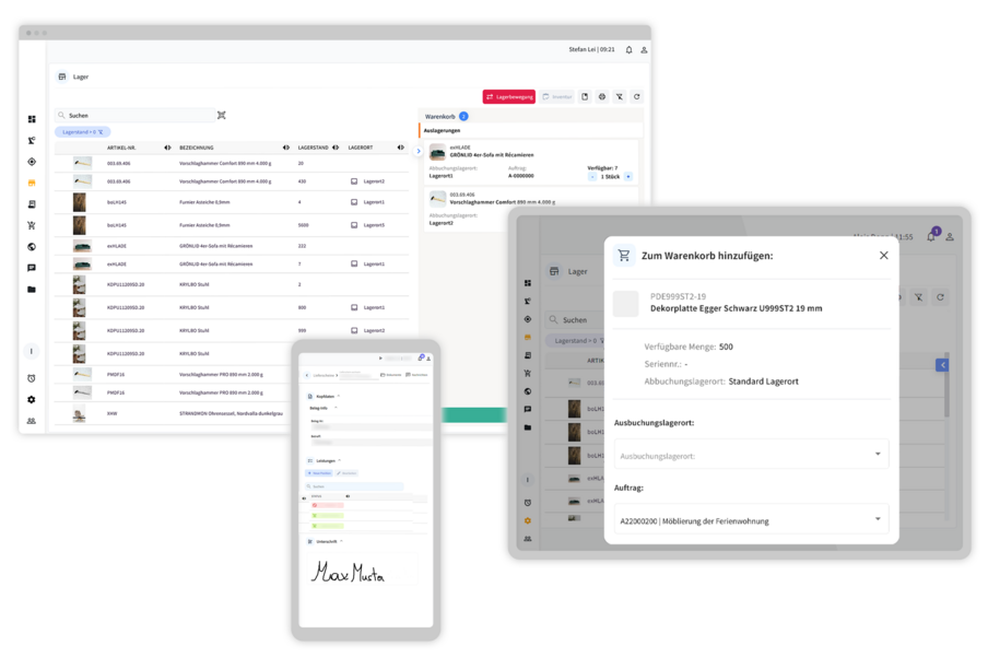
- Lagermanagement: Die Software ermöglicht es, den Materialbestand in Echtzeit zu überwachen. Sie sehen sofort, was an Material fehlt, bestellt oder auf Lager ist.
- QR-Code-Etiketten und Tablet-Scannen: Materialentnahmen werden effizienter und genauer, da QR-Code-Etiketten über Tablets gescannt werden. Dies ermöglicht eine schnelle und korrekte Buchung von Waren, was zu einem besseren Informationsstand führt, z.B. für rechtzeitige Nachbestellungen.
Das Lagermanagement ist in unsere ERP-Varianten integriert
ERP Light | ERP Kompakt | ERP Extended |
|---|
| Lagermanagement | |||
| Beliebig viele Lagerorte je Artikel | Nein | Ja | Ja |
| Beliebig viele Chargen je Artikel | Nein | Ja | Ja |
| Mindest-, Melde- u. Maximalbestand | Nein | Ja | Ja |
| Bestellvorschlag | Nein | Ja | Ja |
| Lagernde, reservierte, bestellte, verfügbare Bestände | Nein | Ja | Ja |
| Dispositionstypisierung | Nein | Ja | Ja |
| Verschiedene Lagereinheiten | Nein | Ja | Ja |
| Bewertung auf Stammdaten oder Inventurebene | Nein | Ja | Ja |
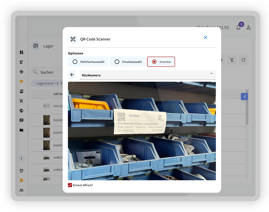
| Inventur mit Barcodescanner | Nein | Ja | Ja |
| Laufende Inventur | Nein | Ja | Ja |
| QR-Code-Etiketten und Tablet-Scannen für Lagerbewegungen | Nein | Ja | Ja |
| Echtzeit-Bestandsverwaltung | Nein | Ja | Ja |
| Projektbezogene Lagerhaltung | Nein | Ja | Ja |
| Anbindung an verschiedene Lagersysteme über Schnittstellen | Nein | Ja | Ja |
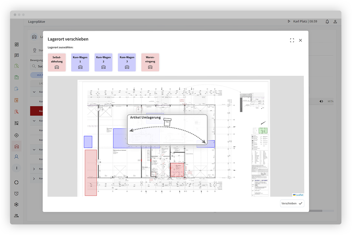
Digitale Lagervisualisierung für mehr Überblick.
Zentro bietet auch eine mobile Lagervisualisierung, die sicherstellt, dass Benutzer, unabhängig von ihrem Standort, leicht finden, wonach sie suchen. Diese Flexibilität und Mobilität sind entscheidende Faktoren, um den Arbeitsablauf zu optimieren und Engpässe zu minimieren.
Insgesamt trägt Zentro dazu bei, die Effizienz im Lagermanagement zu steigern, indem es eine präzise Bestandsverwaltung, Flexibilität bei der Lagerortgestaltung und eine nahtlose Anbindung an verschiedene Lagersysteme ermöglicht. Dies resultiert in einer verbesserten Kontrolle über den Materialfluss und letztendlich in einer gesteigerten Gesamteffizienz der logistischen Prozesse.
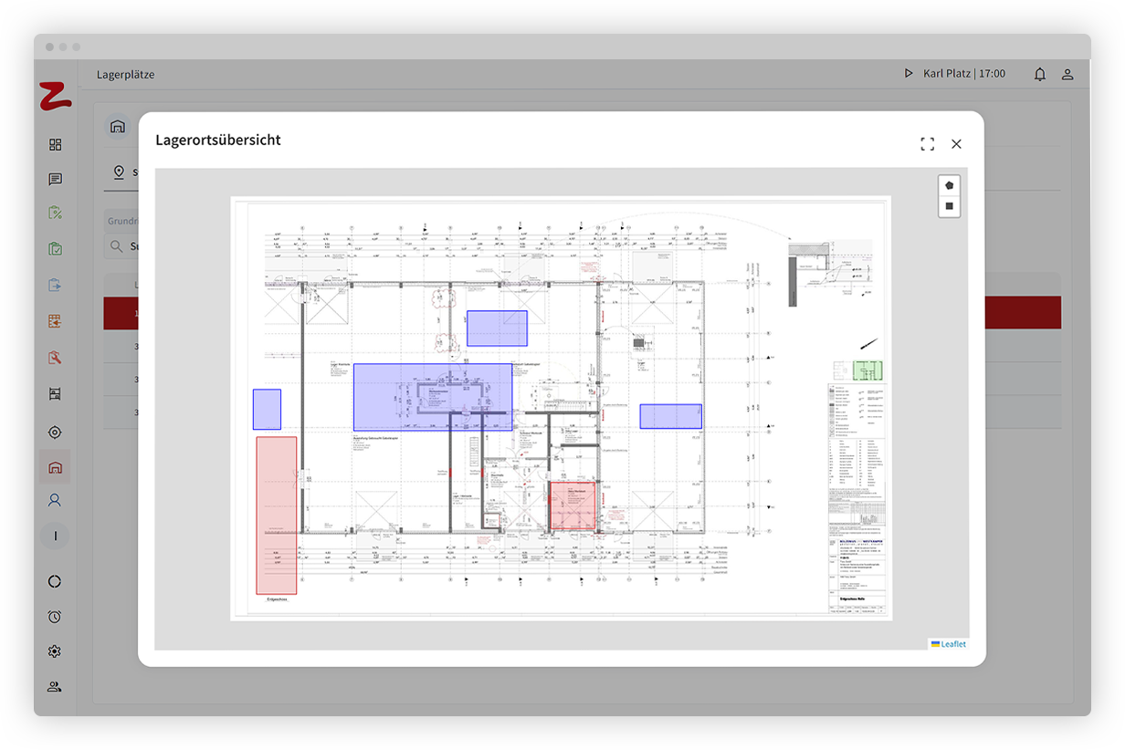
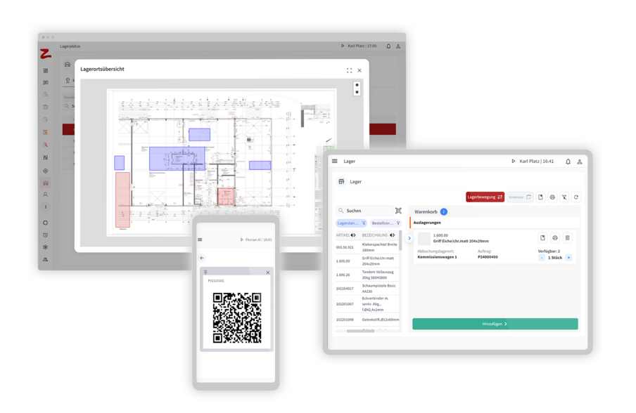
Lagerorte via GPS und auf Grundriss für verschiedene Standorte.
- Lagerorte als GPS-Koordinaten und auf Grundrissplänen visualisiert
- Standortübergreifende Lagervisualisierung
- Farbliche Markierung für projektrelevante Materialien
- Lagerorte mehrerer Standorte im Blick

Projektbezogenes Lager in Containern oder Boxen - auch mobil.
Besonders praktisch ist die Möglichkeit, projektbezogene Lager in Containern oder Boxen aufzubauen. Der Standort dieser Behälter kann sich innerhalb des Lagers ändern oder sogar in ein anderes Lager an einem anderen Standort verlegt werden. Dies bietet einen erheblichen Vorteil für Bauvorhaben oder wenn Teile an externe Fertiger geliefert werden müssen. Wird der Standort eines Lagerorts verlegt, wirkt sich das automatisch auf die dort eingelagerten Teile aus.
Die Lagervisualisierung ist als Zusatzmodul zu unseren ERP-Varianten erhältlich
ERP Light | ERP Kompakt | ERP Extended |
|---|
| Lagervisualisierung | |||
| Visualisierung der Lagerplätze | Nein | Nein | Ja |
| Mobile Lagerplätze (Container, Transportpaletten) | Nein | Nein | Ja |
| Zeitraum bezogene Lagermengenvisualisierung | Nein | Nein | Ja |
| Zeitplan bezogene Mengenreservierung | Nein | Nein | Ja |
| Zeitpunkt bezogene Bestellvorschläge | Nein | Nein | Ja |
| Lagerorte als GPS-Koordinaten und auf Grundrissplänen oder Landkarten visualisiert | Nein | Nein | Ja |
| Standortübergreifende Lagervisualisierung | Nein | Nein | Ja |
| Farbliche Markierung für projektrelevante Materialien | Nein | Nein | Ja |
Profitieren Sie von
- Echtzeit-Bestandsverwaltung
- Mobile Lagerverwaltung
- Standortunabhängige Suche
- Mobile Lagerplätze (z.B. in Boxen und Containern)
- Projektbezogene Lagerhaltung
- Anbindung an verschiedene Lagersysteme
Success Storys unserer Kunden.
OBJEKTAUSSTATTER
“Wir waren lange auf der Suche nach Lösung, die unsere Ansprüche hinsichtlich Innovation, Flexibilität, Transparenz und Einfachheit in der Bedienung abdecken kann. Zentro Go konnte unsere individuelle Anforderung zu 100 % erfüllen.”

Konrad Grömmer
Betriebsleiter
Tischlerei Grömmer

SCHREINEREI
"Der größte Vorteil von Zentro ist für uns, dass alle Prozesse in einer Oberfläche abgebildet sind. Dadurch entsteht eine Transparenz und Nachvollziehbarkeit der Aufträge. Ich habe mich für Zentro entschieden, weil es für mich das beste Programm auf dem Markt ist."

Rüdiger Huschle
Geschäftsführer
Schreinerei Huschle

BAU- und MÖBELTISCHLER
"Es funktioniert alles mindestens so wie versprochen und besser, als wir es uns gedacht haben."

Franz Hackl sen.
Geschäftsführer
Tischlerei Hackl
Sie haben Fragen? Wir beraten Sie gerne.
Wir freuen uns über
Ihren Anruf!
Schreiben Sie uns gerne
per Mail!
Zentro GmbH
Grubbachstr. 71
4644 Grünau im Almtal
Österreich